New Zealand Quarry Map – South Island
$175.00
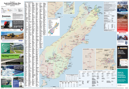
The New Zealand Quarry Maps are designed to give an insightful and comprehensive snapshot of the local quarrying sector.
The two maps (one for each Island) measure 1.2m x 0.83m in size and clearly display more than 600 operating quarries. This includes enlarged zoom-ins on information-dense areas (e.g. Christchurch, Auckland).
The name of each quarry and its operator is shown on the map, as well as production volumes and rock types (where known). Included are aggregate, limestone and other industrial minerals quarries.
Other information on the map:
- Concrete batching plant locations
- Cement plant and cement import terminal locations
- Data about Roads of National Significance
- Aggregate production statistics
Our information has come from a variety of sources, including Inside Resources (www.insideresources.co.nz), quarry operators and other industry contacts, Land Information New Zealand, Statistics NZ, New Zealand Transport Agency and various local and regional councils.