Taranaki Energy & Infrastructure Map
$175.00
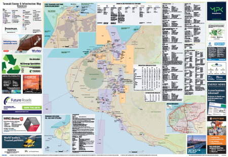
Taranaki is home to a wealth of industries, supporting dairy, oil and gas, electricity infrastructure, and a busy port and airport.
The Taranaki Energy & Infrastructure Map is a large 1.2m x 0.83m poster provides a comprehensive insight into the Taranaki region’s industries, businesses and infrastructure.
The map shows current operating petroleum exploration and mining permits, permit boundaries, operator and partner names and stakes, recent annual and quarterly output statistics, reserves numbers, relevant New Zealand Petroleum & Minerals work programme commitment deadlines, plus a summary of all major producers showing their contact details, overall permit coverage, exploration lead details, gas and liquids pipelines, water depths and field structure shapes.
Other information includes:
- Electricity transmission and generation
- Oil and gas production infrastructure
- Three waters
- Large energy users
- Corporate head offices
- Ports and airfields
- District boundaries
- Iwi boundaries
- Conservation areas
- Quarries
- Waste management sites
- Percentages of company shares across oil and gas fields
- Oil, gas and LPG production forecasts